Showing posts with label Zamberlan. Show all posts

Tuesday, May 7, 2024

Hiking the L.V. Yates Trail...

Return to Phoenix Mountain Preserve

This past Saturday, May 4th, 2024, I went hiking again.Not only did I go hiking again, I also went back to the Phoenix Mountain Preserve. This time, however, I did not make a return visit to Dreamy Draw. Instead, I went back to the beginning: the 40th Street Trailhead. Back on March 25th, I attended a nighttime hike at the 40th Street Trailhead given by REI. It was my first ever visit to the Phoenix Mountain Preserve. The idea of the hike was to complete a short hike in the dark after sunset with a small group of people. As a result, the hike aroused an interest making a return visit to the Phoenix Mountain Trail. Since that first visit, I have returned to the Phoenix Mountain Preserve for three additional visits. Since the Phoenix Mountain Preserve is criss-crossed by trails, I will probably keep going back for the foreseeable future.

L.V. Yates Trail (#8)

After hiking two nearly identical trails at the Dreamy Draw Trailhead, the Perl A. Charles Trail and the Voaz MTB Loop Trail, I decided to hike the L.V. Yates Trail (#8). As you can see from the topographic map from the All Trails website, the L.V. Yates Trail (#8) is a roughly 5 mile "out-and-back" hiking trail.

L.V. Yates Trail (#8)
L.V. Yates Trail (#8), (Source: All Trails)


My initial goal for the hike was to simply follow the L.V. Yates Trail out to the end and then come back.

L.V. Yates Trail Marker


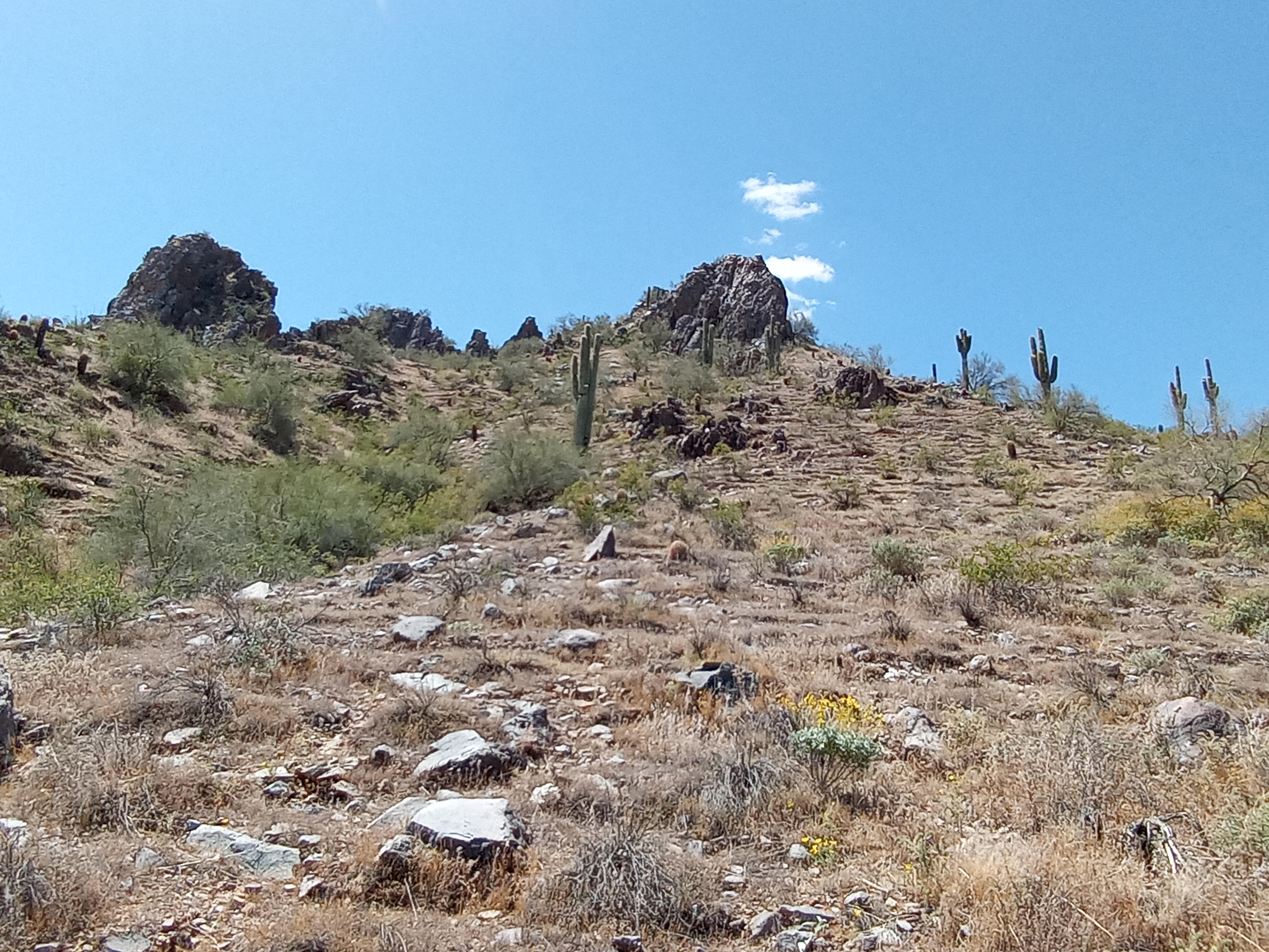
The L.V. Yates Trail consisted of a gradual rise in slope to two saddle points that are neatly placed 1.2 miles between each other. The first saddle point has an elevation of roughly 1,822 feet. The second saddle point is at a lower elevation at 1,770 feet. The trail also goes through a dry stream bed that lies between both saddle points. The L.V. Yates Trail is also largely rocky. There were several instances on the trail where one foot slipped on a rock as I hiked. Like most of the trails at the Phoenix Mountain Preserve, the L.V. Yates Trail connects with several other hiking trails. Therefore, you can combine the L.V. Yates Trail with another trail for a longer hike. However, with the daytime temperatures starting to rise in the Phoenix metropolitan area, you are going to have to start hiking early in the morning if you want to hike six or seven miles.

My Hiking Route on the L.V. Yates Trail

#304/Ocotillo Trailhead

It just so happens that the L.V. Yates Trail meets up with the Piestewa Peak Nature Trail at the second saddle point. From where the two trails met, I followed the Piestewa Peak Nature Trail to the #304 Trailhead. 

End of the L.V. Yates Trail


From the saddle point, the Piestewa Peak Nature Trail appeared to be a short hike to the Ocotillo Trailhead. The view was deceptive as I had to hike down from the saddle point to a narrow dried-out river bed and then back up an incline. The detour to the Ocotillo Trailhead added another half mile to my hike. 

At the Ocotillo Trailhead

At the #304 Trailhead, also known as the Ocotillo Trailhead, there are bathrooms, drinking fountains, and a place to sit down underneath overhead cover, which is known locally as a ramada. Since the #304 Trailhead/Ocotillo Trailhead is located at the Piestewa Peak Park area, parking is also available. The facilities are rather similar to what you would find at the Dreamy Draw Trailhead. Just a note about parking during my hike. When I arrived at the 40th Street Trailhead at around 9:15 AM, I was lucky to park my car in one of the few remaining available parking spaces. When I arrived at the #304-Ocotillo Trailhead at around 11:30 AM, the parking lot for that part of Piestewa Peak Park was pretty much empty. The reason why the parking lot was empty was the RISING temperature.

Slow Going on the Return

Once at the Ocotillo Trailhead, I went to the bathroom, washed my hands, and then looked for a shady place to sit. After eating my peanut butter Clif bar and drinking some water from my Gregory hydration pack (no leaks on this day BTW), I started to notice just how hot it was. Relatively speaking. One thing that I did not notice was my feet being in extreme pain at my half-way point. My new size 11W Zamberlan hiking boots were doing their job. Once my watch indicated that it was 12:00 PM, I got back up and headed back to the Piestewa Peak Nature Trail. Since I was hiking uphill again, it was extremely slow going. My heart rate was going crazy. My breath was short and raspy. Still struggling with allergies, my lungs were struggling. Then there was the heat. It was starting to get quite noticeable. I had to hike step-by-step up the ridge to get back to the saddle point. It was slow going, but it was my only option. Once I got to the saddle point, I sat down on the bench made out of rocks and drank some water. With the terrain of the L.V. Yates Trail now declining, my pace quickened. After hiking through the dried-out riverbed, I reached another rest area. I sat down for a couple of minutes and drank some more water. I then began the ascent to the first saddle point on the L.V. Yates Trail. Again, my pace on the trail to the saddle point was extremely slow with the sun beating down on my head. Once at the saddle point, I sat down once again on the bench made out of rocks and drank more water. I then began my descent back to the parking lot at the L.V. Yates Trailhead. As the temperatures rose, my pace on the trail began to slow and almost become laborious. Everytime I reached a signpost on the trail, I stopped to drink a couple of sips of water. As far as I could tell, I was the only person in my immediate area of the Phoenix Mountain Preserve. Occasionally, I would see a mountain biker or a pair of trail runners off in the distance. The parking lot was starting to get closer and closer. I saw the trail map at the edge of the parking lot. I had finally made it back. Apart from my car and two or three other cars, the parking lot was empty. I found a bench at a ramada to sit at. I took a look at my hydration pack and noticed that I had A LOT more water to drink that I had thought.

Once I got back to my car and took off my hiking boots, I could already picture in my mind drinking a large, frosty mug of Scottsdale Blonde Koelsch by Huss Brewing waiting for me.

Scottsdale Blonde by Huss Brewing


Here is the first batch of the photographs that I took.


Monday, April 29, 2024

Hiking the Voaz MTB Loop Trail, Part 1...

Getting New Boots and a New Hydration System at REI

This past Saturday, April 27th, I drove back down to the Phoenix Mountain Preserve and hiked the Voaz MTB Loop.

Why did I hike the Voaz MTB Trail?

Like I mentioned in previous posts, I recently exchanged my size 10.5 Zamberlan Vioz GTX Hiking Boots for a pair at size 11W at the REI in Paradise Valley in eastern Phoenix. Since the Camelbak hydration system that I used in Iraq back in 2006 has recently started leaking, I picked up a Gregory Nano 22 H2O Hydration Pack - Plus Size. Lastly, since the weather is starting to get warmer, I went ahead and bought the Sahara Sun Hat with Cape by REI. I already had a sun hat for hiking that I bought from Amazon a couple of years ago, but "Why not?" I reasoned.

As a result, I was itching to hit the trail.

Deciding on a Trail to Hike

In my previous visit to Dreamy Draw at Phoenix Mountain Preserve a couple of weeks ago (the subject of a future post here on my blog), I had a rough time using Google Maps to navigate my way on the Perl Charles Memorial (1A) Trail. The information for Dreamy Draw on Google Maps was spotty and incomplete. This time, I was going to use the All Trails app on my cellphone.

Before going to bed, I spent nearly an hour of time looking at all of the trails for the Phoenix Mountain Preserve on All Trails.

My main criteria for choosing a hiking trail was a hike that would be about four or five miles in length. I wanted to give my new hiking boots a good workout, but I didn't want to go on a seven or eight mile hike just yet. I just wanted a medium-length hike without too many issues. I also wanted to try out my new Gregory hydration pack and sun hat.

Since we are at the end of April, the temperatures in the Phoenix area are already in excess of 90 degrees Fahrenheit. Checking the weather forecast, I noticed that the temperature for Saturday, April 27th, was predicted to be in the low 80s due to a storm moving through central and northern Arizona.

With all of that criteria in mind, I decided upon the Voaz MTB Loop.

Map of Voaz MTB Loop Trail
Map of the Voaz MTB Loop


The Voaz MTB Loop isn't an official trail on the City of Phoenix Parks and Recreation website for hiking trails. The Voaz MTB Loop is a combination of several trails, the VOAZ Trail, the Perl Charles Memorial Trail, and the Dreamy Draw Nature Trail. According to All Trails, the Voaz MTB Loop has a length of 4.1 miles and an elevation gain of 793 feet.

Returning to the Dreamy Draw Trailhead

With all of that in mind, I managed to go to bed at 1:30 AM and then get up at 7:30 AM. I got a solid six hours of sleep. After a short trip to my local Safeway to pick up some bottled water for my hydration pack, I managed to arrive at the parking lot for Dreamy Draw at around 10:00 AM. I even managed to find a parking spot at the parking lot on a Saturday morning. Nice.

I took off my New Balance shoes and put on my new Zamberlan hiking boots. I then laced up the boots. Perfect fit, so far. I wanted to know how my feet would feel after hiking four or five miles.

Then, things started to get a little crazy.

I filled up the bladder on my Gregory hydration pack to up to the 3-liter limit. After tightening the cap, I put on the hydration pack on my shoulders. The back of my shirt was SOAKED. There was water all over the exterior of my hydration pack. When I opened the hydration pack, there was water inside the compartment where the bladder is stored. A large amount of water was missing from the bladder. What the hell happened? Fortunately, I bought three 1.5-liter bottles of water when I was at Safeway, so I had plenty of water for my 3-liter capacity hydration pack. I replaced the water that had leaked out and then waited for about one minute. No leaks.

I then put on some sunscreen on my face, neck, and ears. I put on my sun hat. I then made my way to the trailhead.

Hiking the Voaz MTB Loop Trail

When I reached the trailhead with the map of the entire Dreamy Draw area, I opened the All Trails app on my cellphone. I located the entry for the Voaz MTB Loop and then clicked on Start.

Almost right away, I started to have problems using the All Trails app. The beginning of the Voaz MTB Loop was improperly marked on the map. I had to walk around and match the landscape to the terrain on the map on my cellphone. I eventually found the starting point. While holding my cellphone in front of me, I walked forward for about one minute. I observed my location on the map update in real-time. I saw the bright blue line that indicated the part of the Voaz MTB Loop that I had hiked. I was on the correct trail.

Then, just a couple of moments later, I heard a loud chime originate from my cellphone. I was hiking on the wrong trail. I looked at my cellphone and then looked at the terrain. I tried to figure out where I was supposed to be. After about one minute of looking, I found the trail I was supposed to be on. The Dreamy Draw area of the Phoenix Mountain Preserve is littered with hiking trails. There are more trails that what is indicated on the City of Phoenix Parks and Recreation Trail Map.

For the next three hours of hiking, I had the same problem over and over again. I would hike for several minutes before getting a beep from my cellphone, inidicating that I was off the Voaz MTB Loop trail. I would then have to orientate the map on my cellphone to the terrain IOT figure out where I needed to be. At first, it was really annoying. Then it became mildly irritating.

During the hike, I quickly realized that I was largely hiking the same trail, the Perl Charles Memorial Trail (1A), that I had hiked a couple of weeks ago. There were some differences as the Voaz Trail itself is only 0.5 miles long. After I ascended to the saddle point, the highest point of my hike, I realized that I had been at this very location three weeks prior. I recognized the shape of the mountains. I recognized the rest benches made out of stone where I ate a Clif bar and drank some water. Since I have been struggling with allergies and/or a virus for the past two weeks, hiking up to the saddle point was a little on the slow side. However, I wasn't in a hurry. When I needed to take a break, I took a break. After I ate my Clif bar, I had A LOT more energy. After reaching the saddle point, it was literally all down hill from there. Despite the temperature being in the low to mid 80s, I was drinking water like crazy, especially on the way down.

Back at the Trailhead

When I returned to the trailhead, I sat down. During my first visit to Dreamy Draw, my feet were pain at the end of the hike. This time, there was some discomfort in my feet, but the difference was like night and day. After sitting down for a few minutes, I was able to walk back to my car at a relaxed pace. Big difference.

Yes, I did take some photos during my hike. To be honest, it was a hassle trying to switch between the All Trails app and taking a photo with my cellphone. For a brief moment, I considered giving up on taking photos during the hike IOT focus using the All Trails app. However, I decided to go ahead and take some photos despite the problems using the All Trails app. To be fair to the All Trails app, my cellphone is nearing the end of its lifespan. It took an agonizing minute or two for my cellphone to switch from the All Trails app to the camera app. It was painful. Then again, I wasn't in a hurry to get off the trail, so I adapted to the situation.

Lastly, my Samsung Watch 4 ran out of power. Again. This time, I waited until I started hiking to turn on my watch and record my hike. No effect. In addition to my cellphone, I just might have to replace my watch as well. Ugh. If I were to get a new watch, would I get a new Samsung watch or would I go with an Apple watch? I can't say. Before getting a new watch, I will have to play around with the settings on my Samsung Watch 4 and see if I can fix the issue.

Verdict on the All Trails App

All-in-all, I had a somewhat mixed experience with using the All Trails app on my cellphone. Yes, it was a hassle switching back and forth from the All Trails app and the camera app on my phone. I kept forgetting to press the Pause button on the All Trails app before taking a photo. In addition, there were times when I forgot to press the Resume button on the All Trails app. Plus, there is a limit to how far you can zoom in on the digital topographic map on your cellphone. Once you turn on the real-time update on the app, the feature can rapidly drain power from your phone. You definitely need to make sure that you have a backup charger for your cellphone with you on the trail. However, like I wrote earlier, the Phoenix Mountain Preserve is criss-crossed with trails. Many of these trails are either unmarked or poorly marked. The All Trails app is really good at displaying the trail you are hiking and your real-time location. That is a really convenient feature that makes the All Trails app useful. I am not too happy with having yet another service that I have to subscribe to IOT use. I can always go back to using a paper map, I suppose.

Here are about half of the photos that I took. I will make a second post with the other half.


Tuesday, April 23, 2024

New Hiking Boots and Hydration System...

Last week, I found myself making the long drive from my mom's house in Sun City to the REI store located in the Paradise Valley area of Phoenix. It's a long drive no matter what route you take. Usually, I drive east along Thunderbird Road to Cactus Road to the Paradise Valley Parkway. This time, I drove east on Bell Avenue through Sun City, through Peoria, through Glendale, through Phoenix until I got to Tatum Blvd. From there, I drove down Tatum Blvd until I got to the Paradise Valley Parkway. From there, I FINALLY managed to arrive at REI.

It's a good thing that I like the Paradise Valley area.

My primary reason driving along Bell was that I wanted to see what was beyond the intersection of Bell and 43rd Avenues.

The last time I bought a new pair of hiking boots was during the Autumn of 2011. I had recently returned from working six months in Afghanistan and needed a new pair of hiking boots. At the time, I was was living in Reston, VA. The nearest REI located in Fairfax, VA near the Fair Oaks Mall. Since I was wanted to do some hiking in Virginia-Maryland-West Virginia, I bought a pair of Solomon hiking boots for $230.

That was twelve long years ago.

When I moved back to Arizona in November, I took up hiking again. After a couple of hiking trips in the area, the idea occurred to me to buy a new pair of hiking boots. The Solomon hiking boots still worked on hikes to the Thunderbird Conservation Area in Glendale. However, I couldn't let go the idea of buying a new pair of hiking boots.

Anyway, this past December, I noticed that the Zamberlan 1996 VIOZ GTX hiking boots were on sale on REI's webpage. Regularly priced at $350, the hiking boots were on sale for around $230. These hiking boots weren't your typical Merrell hiking boots that would you buy at, say, Dick's Sporting Goods for "day hikes". These Zamberlan hiking boots were designed for extended hiking and backpacking. I had always wanted a pair of hiking boots like the Zamberlan 1996 VIOZ GTX hiking boots. Without driving to REI in Paradise Valley to try on a pair, I bought a pair of the hiking boots at size 10.5 in the grey color.

The hiking boots arrived in the mail two days later.

The first time I wore the Zamberlan hiking boots on the trail was a mixed bag. At the beginning of my hike at Deems Hills in Phoenix, the hiking boots performed remarkably. I felt and hiked like The Terminator. Near the end of my hike, however, my feet felt painful. I couldn't wait to get back to my car, take the hiking boots off, and put on my New Balance running shoes. Little did I know that I would spend the next couple of days recovering from my six mile hike in mountainous desert terrain.

I figured that my new Zamberlan hiking boots just needed to be broken in for my feet.

Subsequent day hikes in Peoria repeated the same pattern. At the beginning of the hike, my feet felt great. After hiking a couple of miles, my feet would begin to ache. I couldn't wait to get back to my car and change shoes.

Two weeks ago, I went hiking in the Phoenix Mountain Preserve. The pattern repeated itself. When my moderate four or five mile hike accidentally turned into a difficult six or seven mile hike, my feet felt as if they were on FIRE by the time I returned to my car. I could barely walk.

A subsequent hike at Papago Park the following week confirmed my hypothesis that my hiking boots were too small and needed to be replaced.

Remembering that REI allowed customers to return purchased items up to one year after purchase, I cleaned off my Zamberlan hiking boots and made the drive to Paradise Valley.

The whole return item procedure at REI was a breeze and without any hassles. Plus, the REI employee that processed my return, Jennifer, was quite helpful. I picked up another pair of Zamberlan 1996 VIOZ GTX hiking boots. This time, I picked up a pair that are size 11W. I even put on the hiking boots and walked around the store for several minutes. Just to be on the safe side, I made a point of walking a couple of miles prior to going to REI.

Zamberlan 1996 VIOZ GTX Hiking Boots

What a relief!!!

I am planning to go hiking this weekend with my new hiking boots.

We'll see what happens and how my feet will feel after a five or six mile hike.

While at REI, I also picked up the Nano 22 H2O Hydration Pack - Plus Size by Gregory.

Nano 22 H20 Hydration Pack by Gregory

The reason for the purchase?

Well, the Camelbak hydration system that the Army gave me to take to Iraq way back in 2006 has probably neared the end of its usefulness. For the past couple of months, my trusty Camelbak has started to leak through the drinking tube. The leak started to occur when I would use my Camelbak bicycling. The Camelbak would leak all over my right thigh. Recently, the drinking tube started to leak while hiking. In fact, just 10 days ago, my Camelbak leaked all over my map during a map and compass course given by REI down at Papago Park. When I went hiking after the class was over, I noticed that my water didn't last very long.

As a result, it was probably time to buy a new hydration system.

Moreover, I doubt that I could buy replacement parts for my Camelbak hydration system.

Why did I choose the Gregory hydration pack over hydration packs made by Camelbak and Osprey?

I really cannot say. The Gregory hydration system just appealed to me. Granted, Gregory produces more elaborate hydration systems than the Nano 22 H20 Hydration Pack. Just check their webpage. For now, I was happy that the Gregory hydration pack that I chose had a 3-liter bladder and a large pocket for storing my rain jacket, Clif bars, headlamp, first aid kit, cellphone charger, USB cable, etc. Now, I no longer have to use my waist pack and fill up the cargo pockets on my shorts.

Since I recently received a notification from REI that Kayaking 101 class scheduled for Saturday, April 27th, at Lake Pleasant has been cancelled, I guess I am going hiking this Saturday. It's time to try out my new gear.